If you are interested in the map, you can buy it as a 100 x 70 cm print in my web shop.
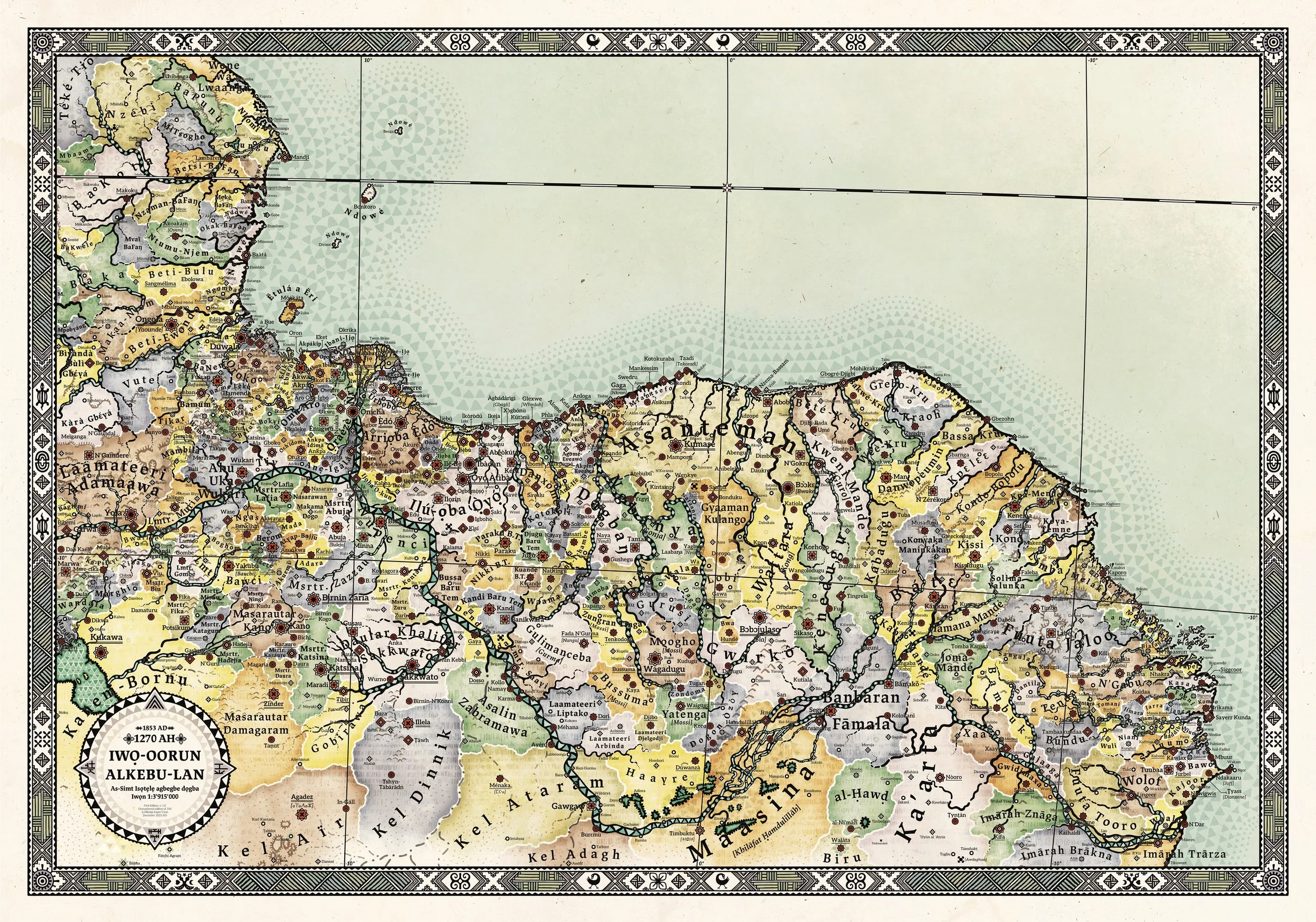
Iwo-oorun Alkebu-lan 1270 AH
I made, more than 10 years ago (2010-2011), my first map of a Africa that could have been, if it had not affected by colonialism because, I was always curious about what civilisation, wonders and cultures surely must have existed there but were not taught in the history lessons in the Swedish school systems.
While it acknowledged ancient Egypt, Carthage, the Scramble for Africa, the Zulu wars, and Ethiopia, was there a significant void regarding the majority of Africa's different parts and historical epochs. The portrayal of colonialism as a force imposed upon a passive and primitive canvas perpetuated a narrative aligned with racist notions such as “the white man’s burden” to “civilise” the perceived “savages.” This narrative, however, stands in stark contrast to the rich tapestry of advanced and diverse cultures, kingdoms, emirates, khalifates, and chiefdoms that proliferated throughout Africa.
This meticulously crafted map delineates nearly 230 entities and over 1,000 settlements, ranging from the Tuaregs in the north to the remarkable University of Sankoré in Timbuktu—a seat of learning that boasted 25,000 students and one of the largest libraries globally, housing 700,000 manuscripts from 1307 until its demise in 1591. The resilience of this intellectual legacy endures, as families in Timbuktu safeguarded many manuscripts as cherished heirlooms until this very day.

University of Sankoré in Timbuktu.
Noteworthy architectural marvels, such as the Great Mosque of Djenné, exemplify the Sudano-Sahelian style, originally constructed in the 13th century and later restored in 1907. The map further showcases non-Muslim empires like the Igbo Kingdom of Nri, the Yoruba Oyo Empire, and the Ashanti Empire (aka Asanteman), each embodying complex statehood and a profoundly rich cultural heritage.

Great Mosque of Djénne..
When the printed maps of my first design ran out, I felt an opportunity to use my deepened understanding of African history and create a new version. I chose to make this map with a focus on West Africa, as a first step to remake the whole map, and since West Africa is the part of the continent I am most fascinated by. I wanted to imbue this map with a new aesthetic expression since I had let European map-making conventions characterised the earlier version.

Yoruba sculptures.
I endeavoured to incorporate West African textile and sculpture patterns and draw inspiration from a handful of existing pre-colonial African maps. For example, I used Adinkra symbols from Ashanti cloths to decorate the frame (seven of which are displayed below), and a Bwa Sun mask as inspiration for the compass design, with Nsibidi symbols from the Efik people to mark the Cardinal directions.

Adinkra symbols used by the Akan people of Ghana in cloth designs.

The frame of the map uses Adinkra symbols in it, the compass is inspired by a Bwa sun mask.
The reimagining presented herein transports us to West Africa in the year 1853, a temporal setting before the intensification of colonialism in 1884. The coasts have their European trade posts removed, but the rest is basically how West Africa was in 1800-1853. In the old map, I had a best-of approach, with the Songhai Empire dominating the middle part of West Africa, an empire that was gone by 1590. In this map, I have instead focused on diversity. The old map portrayed the Sokoto Caliphate as one unified nation with all sub-Emirates included, and had a lot of ethnic “blobs”. Here I have instead let them be independent Hausa Emirates since they still exist in some fashion as independent entities and had quite a lot of independence as vassals to the Sokoto Caliphate. The balance between merging similar related groups or displaying them as separate is always a hard thing to decide, maximize diversity at the risk the map gets cluttered.
This map also includes patterns for different Biomes and hills, mountains, volcanoes and different patterns for small, medium and large rivers.


In conclusion, I extend an invitation for this map to arouse your curiosity, kindle an interest in African history, and prompt contemplation on an alternate and more equitable world.
If you are interested in the map, please consider supporting my art by buying it in my web shop.
